What the Le Teil Earthquake Teaches Us About Seismic Risk in Metropolitan France
One year ago, on November 11, 2019, at 11 :52 a.m., the Montélimar region was shaken by a 5.4-magnitude earthquake.
Christophe Larroque, University of Reims Champagne-Ardenne (URCA); Jean-Francois Ritz, University of Montpellier; Laurence Audin, French National Research Institute for Sustainable Development (IRD); Matthieu Ferry, University of Montpellier and Stéphane Baize, Institute for Radiation Protection and Nuclear Safety (IRSN)
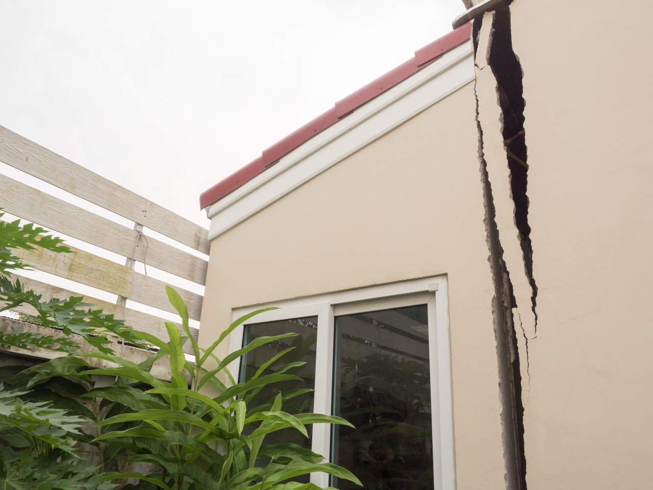
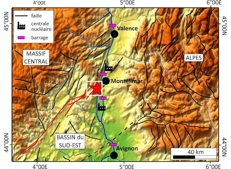
With more than 700 buildings severely damaged and four people injured, this earthquake—felt throughout southeastern France—is the most destructive to strike mainland France since the1967 Arette earthquakein the Pyrenees. This region, bordering the Rhône Valley, is particularly vulnerable due to the presence of several urban areas and major industrial facilities: dams, nuclear power plants, and major road, rail, and waterway networks.
This earthquake compels us to reassess seismic risk in metropolitan France: on the one hand, we must now take into account this type of very shallow earthquake, capable of producing strong ground motion; and on the other hand, we must factor in the possibility of surface rupture—that is, a permanent fracture in the ground—which poses a particular danger to sensitive facilities.
A shallow earthquake and a very distinct ground displacement
A few dozen minutes after the earthquake, it was known that the epicenter was located near the village of Le Teil, with a very shallow focus (the zone where the rupture began deep underground)—between one and three kilometers below the surface—which explains the high intensity of the ground motion and, consequently, the extent of the destruction. In fact, the seismic waves generated at the focus traveled only a short distance before reaching the surface, and their energy was barely attenuated.
Christophe Larroque, Author provided
That same afternoon, the first teams of seismologists set out to install sensors in the field to record aftershocks—these are tremors of smaller magnitudes that invariably follow a major earthquake. The next day, satellite radar images and their analysis using “radar interferometry” revealed vertical displacements in the ground surface exceeding ten centimeters.
For geologists, two observations thus stood out: first, the earthquake’s focus was very shallow; second, the areas of vertical ground displacement observed through radar image processing were aligned in an almost straight line. These observations are very important because they suggest that the portion of the fault that ruptured during the earthquake (known as a “co-seismic” rupture) reached the surface—which, for an earthquake of this magnitude, is a very rare event. So rare, in fact, that as of the date of the Le Teil earthquake, no indisputable co-seismic rupture at the ground surface had yet been documented in metropolitan France.
The formation of a “ridge” on the surface
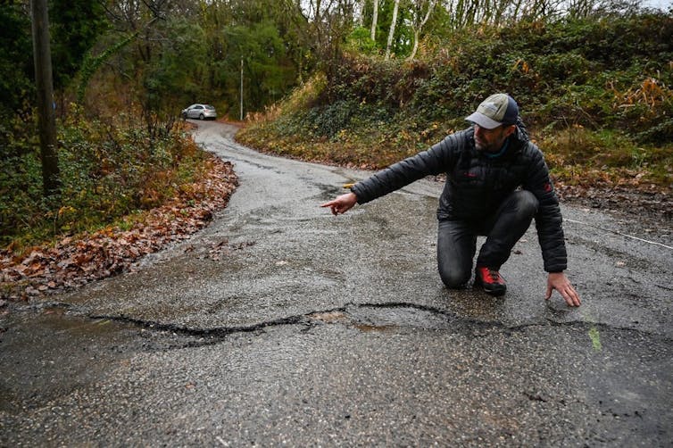
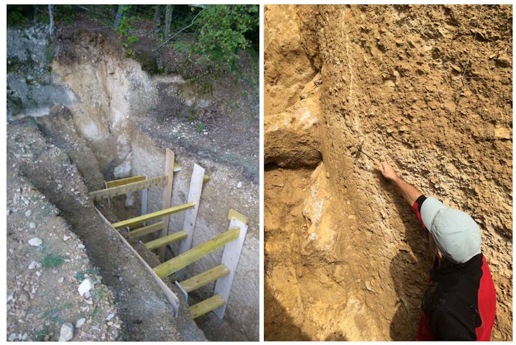
The vertical displacements detected by radar interferometry align along a northeast-southwest direction corresponding to an older fault, the Rouvière Fault. Analysis of these displacements indicates uplift of the southern compartment. On November 13, a team from several French laboratories set out to search for potential surface ruptures. Despite difficulties in the field due to vegetation and rugged terrain, several signs of ground surface rupture were discovered, some showing vertical displacements ranging from 2.5 to 15 centimeters.
Philippe Desmazes/AFP
These measurements also show that the southern segment of the fault has risen, and their distribution confirms that they are indeed the result of the seismic rupture associated with the earthquake reaching the surface.
An ancient fault… but still active
These observations are unprecedented. This is the first time that such a “cosismic” rupture—the rupture of the fault during the earthquake—has been observed at the surface and “in real time” in France. Furthermore, very few such cases have been documented worldwide for earthquakes with a magnitude of less than 5.5.
The Rouvière Fault, along which the Le Teil earthquake occurred, is an ancient fault that was not mapped as active—that is, capable of causing such an event.
R. Lacassin/Wikipedia, CC BY-SA
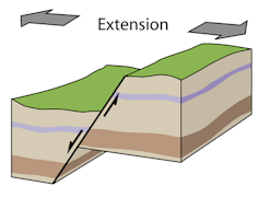
It is about ten kilometers long and forms one of the northern segments of the large Cévennes fault system, which extends over more than 120 km between Lodève and Valence. The most recent significant movements along the Rouvière Fault date back to the Oligocene period, between 35 and 25 million years ago. During the Oligocene, this fault functioned as a “normal” fault within an extensional tectonic regime, coinciding with the opening of the western Mediterranean Sea. Movement along the fault caused the Rhône Valley to subside relative to the Ardèche margin.
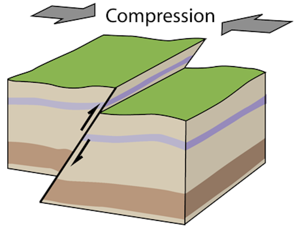
The movements along the Rouvière Fault have reversed
However, during the Le Teil earthquake, the southern block was uplifted. The 2019 earthquake therefore indicates that the direction of movement along the Rouvière Fault has reversed.
RobinL/Wikipedia, CC BY-SA
Fault reversal is a well-known process in the evolution of large geological systems. In this case, the Rouvière Fault operated in a “normal” direction in the past—that is, the block south of the fault was subsiding relative to the block to the north—but recently its slip direction reversed, and the southern block is now rising along the fault plane relative to the northern block.
From this perspective as well, the Le Teil earthquake is particularly interesting because it provides a “real-time” illustration of the reversal of a normal fault—and, consequently, the change in tectonic regime.
Since the 1960s, it was thought that earthquakes in the region could be explained fairly simply by the convergence of the African and European tectonic plates, which generates forces directed northward from the boundary between these plates located south of the Mediterranean. However, observations and modeling conducted over the past two decades have called this single-mechanism explanation into question: it appears that local processes—such as erosion, the melting of the great Alpine glaciers 15,000 years ago, or the circulation of fluids within the Earth’s crust—are also capable of triggering earthquakes.
Human activities on the Earth’s surface are also discussed as potential triggers of earthquakes. In the case of Le Teil, the removal of a large mass of rock from a quarry located above the fault may have caused the event.
In short, the origin of the forces that cause “intraplate” earthquakes in Western Europe is not yet fully understood and is the subject of extensive research.
See also:
Earthquake in the Aegean Sea: What Do Scientists Know After a Few Days of Investigation?
Exploring the past to better understand the present and the future
Paleoseismologists study past earthquakes. In this case, they are studying the Rouvière Fault and the other faults that make up this part of the Cévennes fault system to determine whether they have previously caused surface ruptures over the past 2 million years. They analyze whether deformations associated with earthquakes (such as cracks, displacements, folds, and tilting) affect the most recent sedimentary layers (such as slope debris, fluvial alluvium, and sand) in the trenches they dig across the faults.
Christophe Larroque, Photo courtesy of the author
They are thus seeking to determine the ages and displacements caused by these deformations in order to estimate the frequency and magnitude of ancient earthquakes. By assuming that a fault’s current behavior is similar to its past behavior (the principle of “actualism”), paleoseismological data can be used to assess the probability that a fault will generate an earthquake over a given period of time.
Let's hope that the ongoing work in the Le Teil region will provide enough data to enable us to conduct this seismic risk assessment for this part of the Cévennes fault system.![]()
Christophe Larroque, Associate Professor, University of Reims Champagne-Ardenne (URCA); Jean-François Ritz, Research Director, University of Montpellier; Laurence Audin, Director of Earth Research , French National Research Institute for Sustainable Development (IRD); Matthieu Ferry, Associate Professor of Geomorphology, University of Montpellier and Stéphane Baize, Researcher in Earthquake Geology, French Institute for Radiological Protection and Nuclear Safety (IRSN)
This article is republished from The Conversation under a Creative Commons license. Readthe original article.