Mayotte Diary: A Strange Sense of Complacency, Just Hours Before the Disaster
**Although the severity of Cyclone Chido had been forecast, the people of Mayotte were ill-prepared for the impact. Caught up in this tragedy, Fahad Idaroussi Tsimanda, a geographer and specialist in natural hazards, seeks to understand the public mindset and the government’s failures.
His logbook provides a detailed, hour-by-hour account of the disaster. Part One.
Fahad Idaroussi Tsimanda, University of Montpellier
Thursday, December 12
For the past five days, reports about the cyclone have been circulating on social media. Forecasts predict that “Chido” will pass over the island of Mayotte, and as time goes on, the severity of the storm becomes increasingly clear, raising fears of significant loss of life and property damage. The prefecture and the president of the departmental council have addressed the media to inform the public of the danger posed by the storm. They are urging residents to exercise caution, reinforce their roofs, shelter their animals, avoid taking unnecessary risks, and stock up on supplies—food, water, candles, and more.
As a geography teacher, I then received a message from the Mayotte Board of Education informing me that we would not be working on Saturday in high schools and other educational institutions due to the threat.
As a geography professor and specialist in natural hazards, I am well aware of the impact Chido could have on the island. The cyclone threatens infrastructure, but also—and above all—human lives. Residents of informal settlements, often located on unstable slopes or in flood-prone areas, are particularly at risk.
Friday, December 13
I start the day by going to fetch straw in Maevarano, in the western hills above Acoua, the village where I live, nestled in a volcanic cirque in northwestern Mayotte. I spend the next five hours in the countryside to ensure the safety and well-being of my goats, sheep, geese, and ducks during the crisis. I then head toward the center of the island to buy some food for my young child and packs of water.
I know that my house, built with cinder blocks and concrete and equipped with a securely anchored roof, keeps me relatively safe from danger. There are no informal structures in my neighborhood. However, not far away, on the hills of Acoua (in Marovato, Mronipopo, and Tsimitohy) and in several localities in the municipalities of Bandraboua, Koungou, and Mamoudzou, slums are home to thousands of people living in makeshift shelters made of sheet metal, wood, and salvaged tarps. Will they be evacuated in time? Will they agree to follow the authorities’ instructions and head to the shelters?
In 2019, following the passage of Cyclones Kenneth and Belna, some migrants from the Kawéni slums (in the Mamoudzou metropolitan area, Ed.) refused to be evacuated, largely out of fear of being robbed. Will the shelters—which are often too small—be able to accommodate everyone?
With just a few hours to go before the hurricane hits, residents and local officials don’t seem to be taking the threat very seriously. No one is rushing to the supermarkets to stock up, and no one is scrambling to gas stations to fill up their tanks.
In Mayotte, there is a long-standing belief that the island will always be protected by Madagascar’s natural barrier. In this region, most cyclones, which form to the east, eventually make landfall in Madagascar, thus sparing Mayotte, which lies to the west. Furthermore, for many years, security and migration issues, as well as concerns about purchasing power, have taken center stage. Few people have learned to seriously prepare for the risks posed by cyclones.
Here, documents such as the municipal emergency response plan (PCS)—which enables local governments to organize rescue efforts—and the municipal information document on major risks (DICRIM)—designed to promote prevention and raise public awareness—are not up to date, if they exist at all. Often poorly drafted, they have never been tested. Among the 16 municipalities at risk of tsunamis, only the municipality of Chirongui has marked its refuge zones with signs to inform residents of the locations where they can gather in the event of a tsunami risk.
In several towns such as Acoua, Mtsamboro, and Bandraboua, no tree pruning has been carried out. In the town of Acoua, the municipal police patrol all day long to inform the public about the risks of this phenomenon and the proper precautions to take, using audio messages broadcast through a megaphone. Unfortunately, it is barely possible to hear what is being said, even just a few meters away from the vehicle. For those living several meters from the road or in areas where vehicles cannot travel, the message is completely inaudible.
Saturday, December 14
Since 10 p.m. yesterday, Mayotte has been under a red cyclone alert. Technically, no one is allowed outside anymore. Yet life seems to be going on as usual; people are out and about, going about their business, and don’t seem particularly worried.
Very early in the morning, the island is placed on a purple alert. I’m staying home in Acoua with my family. Between 6 a.m. and 9 a.m., it rains but there is no wind. Despite the gravity of the situation, I hear people walking outside; on social media, several people are making sarcastic comments about the events: according to them, the island is under a purple hurricane alert even though nothing is happening.
At 9 a.m., the first gusts of wind can be heard. The metal sheets used as fences, poorly secured, clang against each other or scrape against the walls of houses. The telephone network and electricity are cut off. The wind picks up and brings rain; the metal sheets continue to dance about, damaging cars parked along the roads. Other projectiles, such as pieces of rafters or pebbles, fly through the air.
Between about 10:30 and 11:30 a.m., the eye of the storm passes over Mayotte. Although the winds die down, the sky briefly clears, and the sea calms, this lull is deceptive. It is therefore crucial to stay indoors. Through the windows, I see adults—including a deputy mayor—heading out into the streets to observe and film the damage, with a surprisingly relaxed demeanor.
Around 11:20 a.m., all of a sudden, the wind picked up again with unprecedented force. People still outside were caught off guard and rushed home or to neighbors’ houses to take shelter. Sheets of metal were blown several meters into the air, and power lines were torn down. This second phase of the cyclone ended around 12:30 p.m., marking an hour of terror.
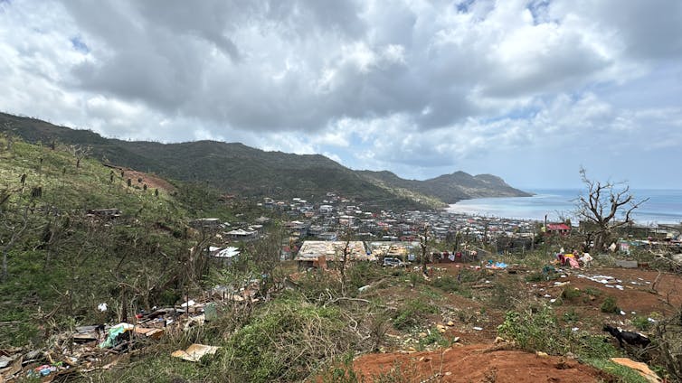
Around 4 p.m., I decided to go outside to assess the damage. On the hills, stretching from the south-southeast to the north-northwest, the lush landscape that once characterized the village has vanished. The few trees still standing, mainly mango trees, have had their branches torn off. How long will it take for the jackfruit, coconut, and other fruit trees to regain their vigor and bear fruit again? The village of Acoua is literally disfigured, like a plucked Mahoran rooster. In the streets, sheets of metal, branches, and overturned trash cans lie on the ground, blocking the way and preventing cars from passing. Yards are destroyed, and the roofs of some houses—including those of my relatives (uncles, aunts, etc.)—have been torn off by the wind.
So I decided to take my motorcycle to check on my livestock. The building that housed my animals had been blown to pieces by the force of the wind. On my way back, I heard that the roof of a hut had fallen on a woman in her fifties, killing her instantly. In the slums, how many victims will there be? Hundreds? Thousands?
I'm heading home, hoping that we'll be able to stay strong in the face of this challenge.
Fahad Idaroussi Tsimanda, Geographer, Research Associate at LAGAM, University of Montpellier, University of Montpellier
This article is republished from The Conversation under a Creative Commons license. Readthe original article.