[LUM#5] In Search of Blue Gold
It provides us with pure water straight from the tap. It protects us from flooding. Welcome to the karst—this underground “Swiss cheese” that harbors precious groundwater reserves, especially in our region.
A true treasure lies hidden beneath our feet. Kilometers of tunnels and cavities carved into the limestone form a complex and little-known network that harbors an invaluable resource: an abundance of “blue gold.”
How deep do these passages extend? How much water is stored in the cavities? These are crucial questions for hydrogeologists exploring karst. “The geometry of these structures allows us to estimate the volume of available water, and their morphology can provide insights into the flow dynamics within karst systems, ”explains Hervé Jourde, a researcher at the Hydrosciences Montpellier laboratory.“This is valuable information: we’re talking about the water resources on which local populations depend,” explains the specialist.
Deep within the Earth
In France, more than 65% of the groundwater used to supply drinking water to the population comes from karst formations. This is the case in Montpellier, where the water that supplies the metropolitan area is pumped directly from karst conduits at the source of the Lez River.“It’s very high-quality water right on the city’s doorstep, which meets 80% of the local population’s needs,” explains Hervé Jourde. Will this resource be sufficient to supply an ever-growing population? Can it handle the summer peak demand typical of the region?“To find out, we need to explore this network at great depths in order to estimate the available volumes,”replies the researcher ( Multiscale Evaluation of the Hydrodynamic Properties of a Karst Aquifer (Lez, France), in Hydrogeological and Environmental Research in Karst Systems, 2014).
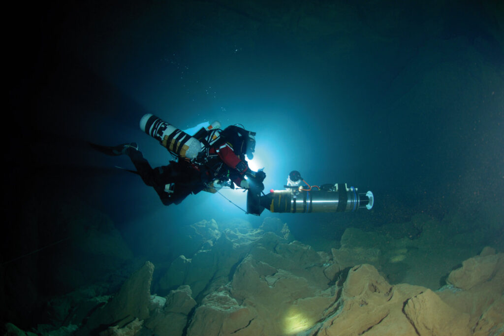
These are true expeditions into the Earth’s depths, led by cave divers who submerge themselves in total darkness to map the karst landscape.“Beyond 200 meters, divers can no longer continue, so we can use robots designed for these explorations,” explains the hydrogeologist, who is collaborating with researchers from the Montpellier Laboratory of Computer Science, Robotics, and Microelectronics (LIRMM) and the diving association PlongéeSout through the Aleyin project.
Mitigating the Severity of Floods
This research is all the more important given that karst also plays a major role in flood events. “When water levels in the karst are low, rainfall is first stored in the fractures and channels, which limits the risk of flooding downstream,” explains Hervé Jourde, who describes karst as “a real asset for mitigating hydrological risk.” A better understanding of the karst system would thus make it possible to refine flood forecasts during heavy rains—and even protect us from rising water levels. “We could strategically position pumping stations to regulate groundwater levels and limit the severity of flooding,” explains Hervé Jourde.
Check out theUM podcasts,UM available on your favorite platform (Spotify, Deezer, Apple Podcasts, Amazon Music, etc.).